How well were the Covid-19 lockdowns in the spring of 2020 actually followed? Views from space provided an answer to this question. Launched in 2017, Europe’s Sentinel 5P Earth observation satellite showed substantial reductions in nitrogen oxide concentrations over major cities like Paris, Madrid, and Rome—corresponding to the slowing down of public life in the EU. Less traffic meant fewer emissions and therefore less air pollution. The precision of the data is little short of miraculous. From an altitude of more than 800 kilometers, Sentinel 5P measures light across a 2,600-kilometer swath of the Earth’s surface in one second. It also measures seven kilometers ahead in the direction of flight, for it moves at a speed of nearly 28,000 km/h—or 7.8 km/s. As it turns out, it has also provided Earth-bound policy makers with information about the effectiveness of their anti-Covid measures.
But artificial satellites are not only useful for analyzing policy decisions. They and their data have become a part of everyday life, with an apparently limitless range of applications. “There wouldn’t be any connectivity on Earth without space,” says Elodie Viau, Director of Telecommunications and Integrated Applications at the European Space Agency (ESA). “There wouldn’t be any navigation, security, or traffic safety systems. Space is the heart of all our connectivity and mobility systems—and the engine for quantum leaps in innovation toward what will become seamlessly integrated, super-intelligent, and high-performance hybrid infrastructures.” Ms. Viau is one of eleven top experts from leading European aviation and aerospace enterprises whom Porsche Consulting queried about the future of the industry in Europe.
Hunting drugs and tax evaders
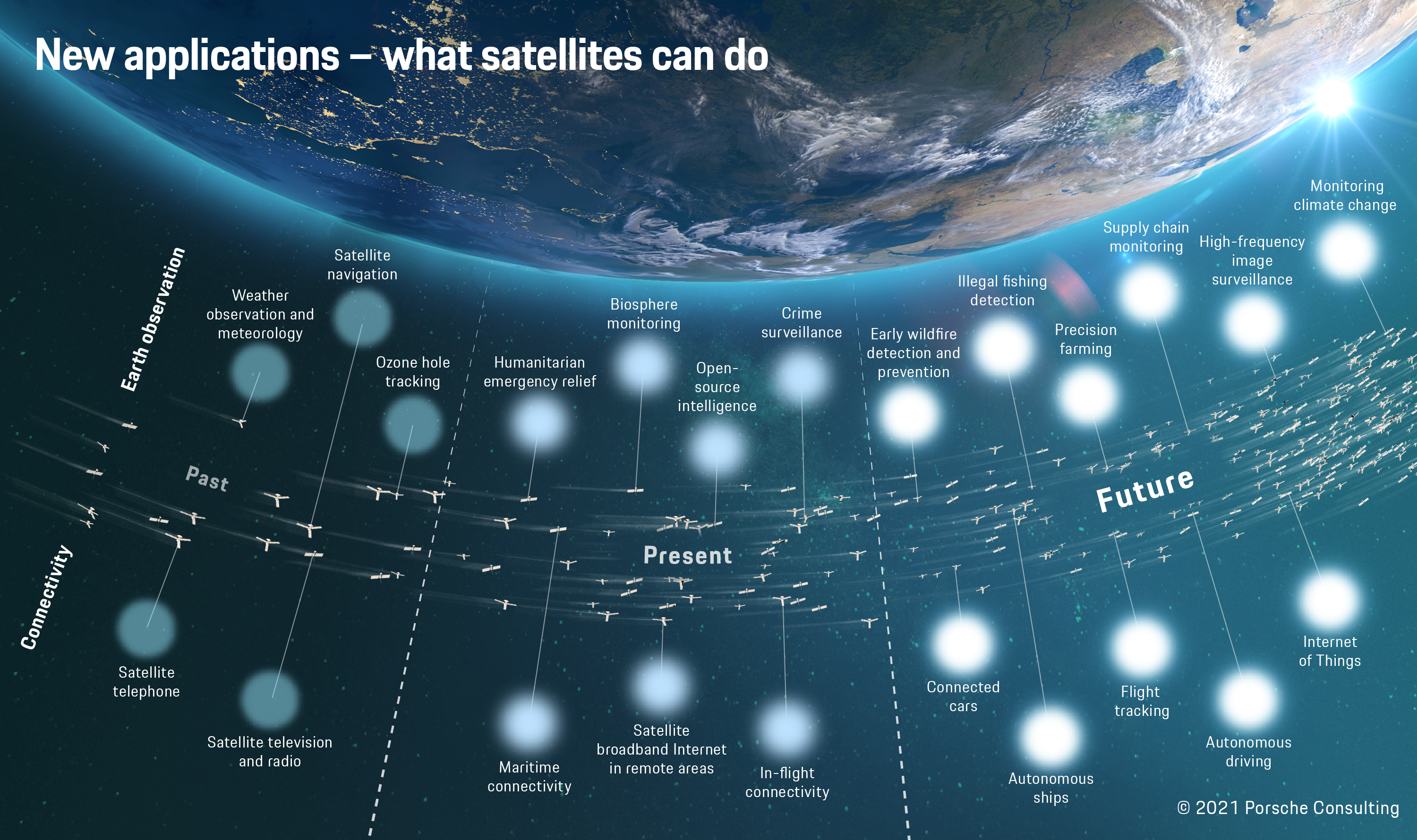
The satellite age began with Sputnik on October 4, 1957. A few years later satellites were already being used to monitor the climate and predict weather. In the mid-1980s Motorola developed the Iridium system for global communications. By the mid-1990s the most popular services included GPS, Galileo, GLONASS, and Beidou, which enable such advances as navigation systems in cars. Today, services from space are used in nearly all areas of our lives: examples include satellite calls from remote areas, credit card payments, TV shows, and Internet access on cruise ships and planes. Earth observation satellites provide rapid imaging of natural disasters and accidents. When the Ever Given container ship blocked the Suez Canal this past March, satellite images showed the growing line of nearly 400 ships on an hourly basis, letting shipping companies opt early on for a detour around the Cape of Good Hope. "Satellites already have enormous capacities to monitor the Earth—and the availability of space-based data will continue to rise as a result of innovative technologies and start-ups," says Dr. Arne Gausepohl, Managing Director of OHB Digital Services GmbH. "The data enable decision makers in government and business to efficiently and independently assess negative effects on the global economy, for example, or maritime incidents like the recent one in the Suez Canal." Police forces and administrative bodies are also making use of the eyes in space. During the Greek debt crisis, the country's tax authorities used Google Earth to find unregistered swimming pools in their search for concealed wealth and luxury tax evaders. Investigators in California have their sights on illegal cannabis farms. Plans call for satellites to monitor the oceans with the aim of ending illegal fishing. Earth observation is the focus of Maxar Technologies and Planet Labs, two US-based companies who offer their customers high-resolution images of traffic flow patterns, military vehicle movements, and the effects of natural disasters. Established space actors like ESA and its Copernicus program also monitor the planet for purposes such as measuring atmospheric concentrations of CO₂. Space-based communications will become very important in the coming years as projects and companies like Starlink and OneWeb seek to ensure Internet access in the remotest parts of the globe.
Satellite data will also benefit mobility. Connected cars will have broadband Internet everywhere and at all times, enabling over-the-air (OTA) updates of their operating systems and letting drivers activate higher performance or extra services like automated driving on demand. Highly accurate maps will make driverless cars safer. Precision location of landmarks like lamps and traffic lights along streets will help cars determine their own positions and calculate distances to other moving objects more exactly. Because traffic and the associated rules on oceans are less complex than on roads, crewless ships might soon by plying the seas and ushering in an era in which "all things are autonomous"—controlled by artificial intelligence and monitored via satellite. Accidents like the blockage of the Suez Canal might then be prevented. "Thanks to a combination of satellite navigation and autopilot systems, ships could find their own ways through canals or into ports in the future," reports Dr. Ralf Ziebold from the Nautical Systems group at the German Aerospace Center (DLR), who works on precision ship localization. "Control software should be able to reliably master the complex dynamics of large ships and prevent human error like the incident in the Suez Canal," he says. But localization systems would then need to be accurate down to ten centimeters, whereas navigation systems in cars today can be off by up to ten meters. To achieve the requisite precision for automated control, canals and ports would have to be equipped with reference stations. With precisely known positions, these stations would considerably increase the accuracy of satellite navigation systems by means of corrective signals to the ships.
New satellites—lightweight and low-priced
Around the world, established companies and start-ups alike are working on new applications and developing innovative business models. “The race to space is underway, with different manufacturers and operators launching ever more satellites every year,” says Joachim Kirsch, Senior Partner for Aviation and Aerospace at Porsche Consulting. That was hardly conceivable until just a few years ago. The satellite business and access to space were considered the realm of governments and their space agencies. But this has changed, for a number of reasons. As Kirsch explains, “Cost-efficient small-scale satellites, some of which have a mass of well under 100 kilograms, are enabling relatively economical access to space.”
They are joined by new launch systems that carry payloads for a fraction of previous costs. “Small launchers—just like small satellites—will become an integral part of the space economy,” predicts Christian Schmierer, Co-CEO of the German start-up HyImpulse, in conversation with Porsche Consulting. “They’ll function like taxis by sending individual satellites quickly, directly, and comparatively cheaply into the desired orbits. That will enable rapid replacement of single satellites in larger constellations.”
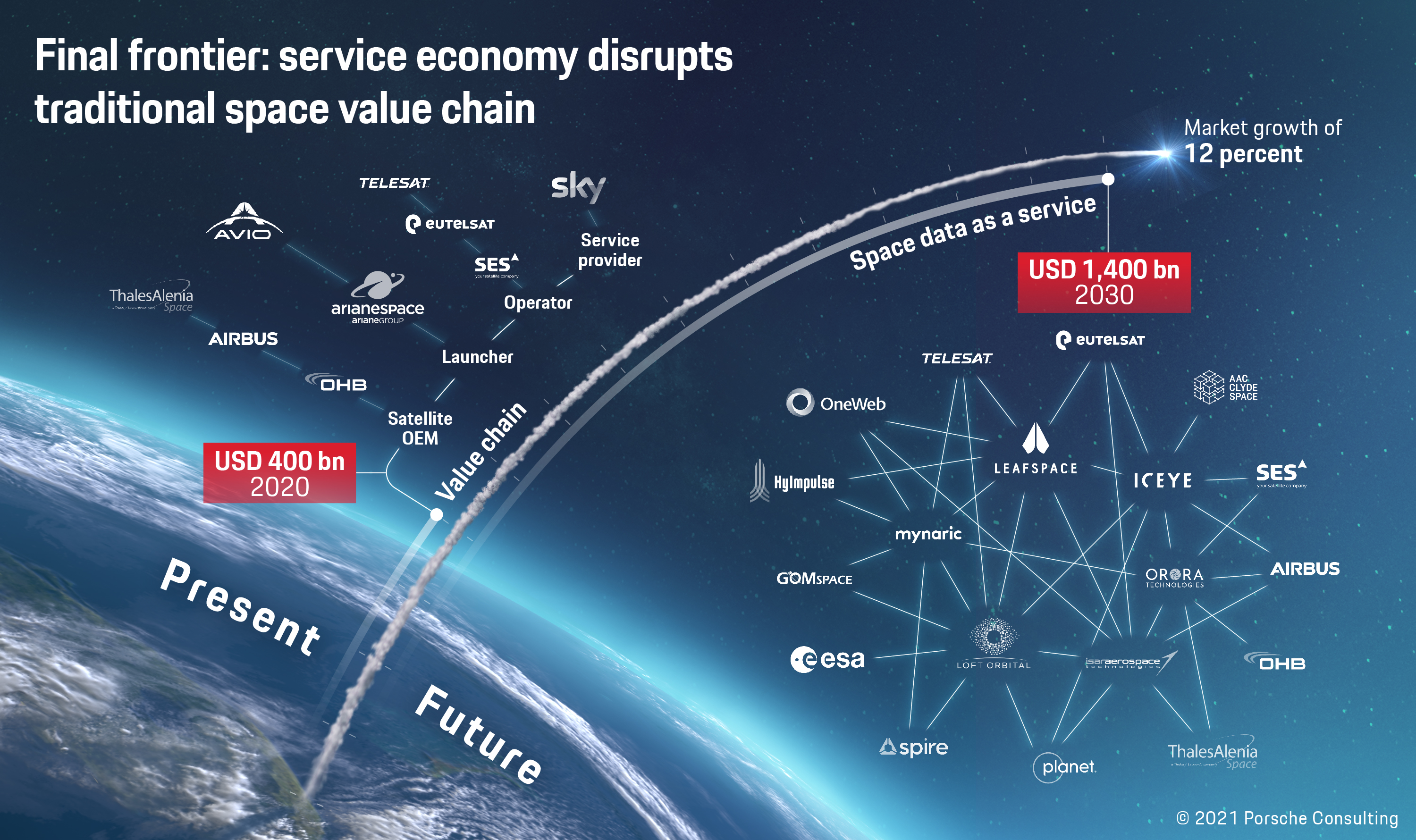
Small satellites and launchers have triggered ever greater dynamism and disruption in the industry. Hundreds of start-ups, along with companies from other industries, are crowding into the market and setting up shop in niche areas along the entire value chain with new business models, technologies, and applications. In July 2021 alone, two companies—Astra Space and Planet Labs—were listed on the stock market with values of over a billion dollars. The potential for profit is high, with industry sales expected to reach 1.4 trillion dollars in 2030, up from 400 billion in 2019. Among other things, the newcomers promise an unprecedented pace in moving into space. “Speed and simplicity are key,” says Pierre-Damien Vaujour, CEO of the Loft Orbital Solutions satellite service provider, in conversation with Porsche Consulting. “There will always be projects for very sophisticated end users that run for five years under strict supervision and cost half a billion euros. But there are ever more users in the defense, research, and commercial sectors who view space simply as a source of services and want to be there in nine months.”
Just one rocket for 60 satellites
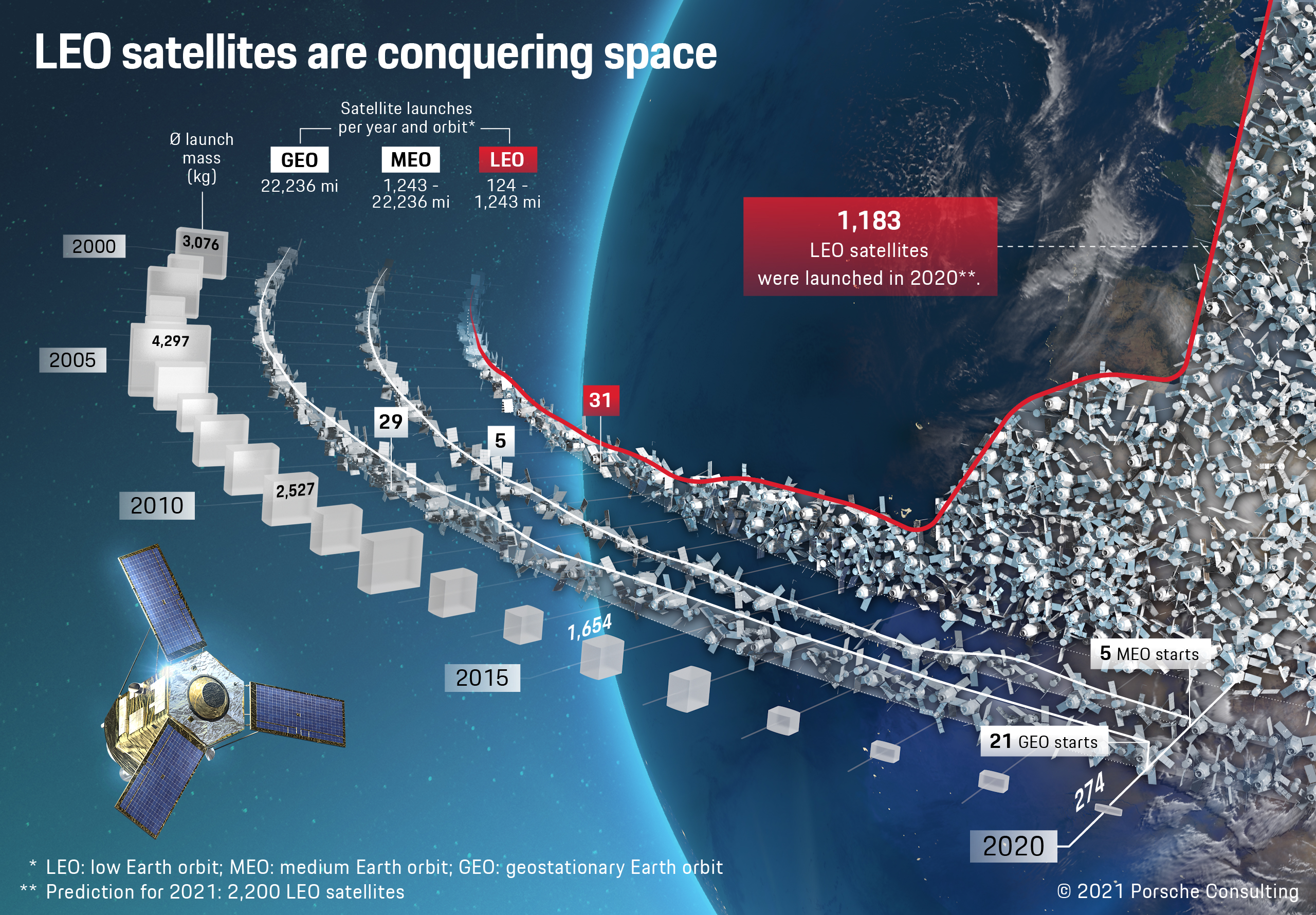
Space is bustling with activity. In late April of 2021 nearly 4,100 active satellites were orbiting the Earth, with more arriving at an unprecedented rate. Nearly 1,300 new satellites were launched in 2020 alone—the highest number in space history. By April of 2021 they were joined by about 850 more, so this year too is on a record-breaking course. An especially active player is Starlink, the constellation operated by SpaceX, which had sent approximately 1,800 satellites into space by May of 2021.
Most of the active satellites are from the USA (around 2,500), China (around 430), and Russia (around 180). The majority are in low Earth orbit (LEO), meaning an altitude of 200 to 2,000 kilometers. LEO currently has more than 3,300 satellites, including the International Space Station (ISS), Iridium's communication satellites, and numerous spy systems. LEO is also where most of the new satellites are sent—1,183 of them in 2020. This invasion of space was made possible by a dramatic reduction over the past decade in satellite size and weight. They no longer weigh an average of several tons, but instead only about 250 kilograms. This means entire flocks can be sent into orbit by a single rocket at a favorable price. Starlink, for example, shoots up to 60 satellites into space with one Falcon 9 rocket—twice a month on average. Their number could reach 30,000 in the next few years. Criticism is on the rise, because more satellites mean a greater likelihood of collision. Already a problem for satellites and space stations, uncontrolled waste could become markedly more serious in a few years due to projects such as Starlink. There are currently no binding international regulations for the disposal of inactive satellites. The ESA at least is planning to start removing failed satellites and larger pieces of debris in 2025 as part of its ClearSpace-1 mission. A specially designed spaceship will approach the debris, secure it with robotic arms, and bring it down into the atmosphere where both will promptly burn up.
Finding and forming successful business models
The most lucrative segment of the satellite market is what is called “space data as a service,” or the sale of data to end customers. “My top megatrend is real-time Earth observation, because it generates content that sets entire value chains into motion instead of simply transporting other people’s data,” says Marco Fuchs, CEO of the northern German aerospace systems provider OHB SE and its subsidiary OHB System AG. OHB’s Digital business unit is active in space data as a service, offering its customers the ability to track ship movements in close to real time, for example, or the latest climate and environmental data.
The breakthrough in the satellite industry is still in its early stages. All players have the chance to position themselves favorably in this growth market. Porsche Consulting has been advising clients for more than ten years in the aviation and aerospace sector, and supporting them in the race to space. Its specialties include choosing the right business models and basic market positioning such as vertical integration along the value chain. Its experts also guide end-to-end industrialization. “On the one hand there are considerably more satellites, yet on the other hand they have to be produced in shorter development cycles and show considerably greater flexibility,” notes Kirsch. “This requires an industrialization process along the entire product life cycle,” he adds, “from product engineering to after-sales services.”
The consultants can also work with space companies to check the economic viability of possible applications for space data as a service, in order to identify promising strategic use cases. Thanks to their broad client base, the experts have a sound grasp of the potential added value of space data in different industries. “It’s crucial not to be misled by hype,” notes Kirsch. “The business model has to be right—that’s the only way to be successful in the race to space.”
Data mean sales
The value chain in the satellite business used to be divided up in large part among the launch rocket manufacturers, satellite producers, satellite operators, and service providers. These boundaries are becoming increasingly porous. A trend toward verticalization is becoming more pronounced as companies cover multiple steps in the value chain (e.g., satellite construction, launch, and operation as well as processing the resulting data) and offer their customers complete "space data as a service" packages. The motivation is clear: more than 90 percent of sales are customer-oriented, such as the provision of data. Moreover, manufacturers can avoid becoming dependent on the satellite business with its sporadic ordering cycles, and instead enjoy continuous plannable sales on the basis of, e.g., monthly subscriptions. For their part, customers are not eager to deal with the challenges of space; they simply wish to make use of the data—and are willing to pay a surcharge for the complete service. "It's strategically and structurally advantageous in my opinion to make business models broad enough to cover the entire value chain and offer everything from a single source," says OHB CEO Fuchs.
OHB and Airbus group are two of Europe’s most prominent providers in this field. Airbus offers proprietary satellite imagery and geodata analyses to its customers, which include defense, security, and intelligence agencies. OHB also offers space data as a service from its OHB Digital business unit, with satellites expected to provide data on climate change and pollution, or for fishing and farming. In addition to major players on the European market, smaller and lesser-known satellite makers like GomSpace and AAC Clyde Space are also broadening their activities. AAC Clyde Space, for example, wants to launch and operate three satellites in 2022 that will help the Canadian Earth observation company Wyvern support the agricultural sector in optimizing harvests and monitoring fields for harmful plants and animals.
Info
Text first published in Porsche Consulting Magazine.